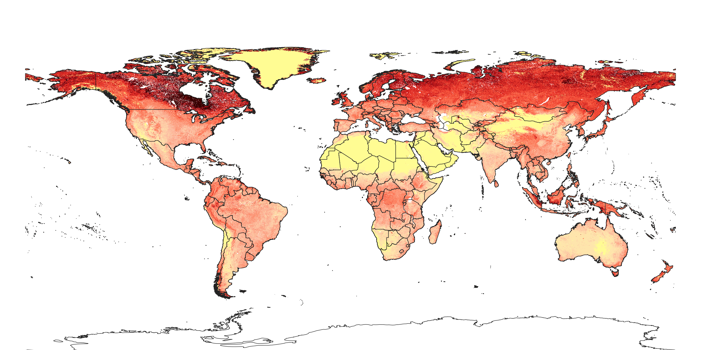
Soil organic carbon stock in kg/m2 for 5 standard depth intervals (0–10, 10–30, 30–60, 60–100 and 100–200 cm) at 250 m resolution

Description
Soil organic carbon stock in kg/m2 for 5 standard depth intervals (0–10, 10–30, 30–60, 60–100 and 100–200 cm) at 250 m resolution. To convert to t/ha multiply by 10. Derived using soil organic carbon content (https://doi.org/10.5281/zenodo.1475457), bulk density (https://doi.org/10.5281/zenodo.1475970) and coarse fragments (https://doi.org/10.5281/zenodo.2525681), predicted from point data at 6 standard depths. Depth to bed rock has been ignored, hence total stocks might be about 10–15% lower then reported. Processing steps are described in detail here. Antarctica is not included.
To access and visualize maps use: https://openlandmap.org
If you discover a bug, artifact or inconsistency in the maps, or if you have a question please use some of the following channels:
- Technical issues and questions about the code: https://gitlab.com/openlandmap/global-layers/issues
- General questions and comments: https://disqus.com/home/forums/landgis/
All files internally compressed using "COMPRESS=DEFLATE" creation option in GDAL. File naming convention:
- sol = theme: soil,
- organic.carbon.stock = variable: soil organic carbon stock in kg/m2,
- msa.kgm2 = determination method: derived from organic carbon content, bulk density and coarse fragments,
- m = mean value,
- 250m = spatial resolution / block support: 250 m,
- b0..10cm = vertical reference: 0-10 cm layer below surface,
- 1950..2017 = time reference: period 1950-2017,
- v0.2 = version number: 0.2,
Files
sol_organic.carbon.stock_msa.kgm2_m_250m_b0..10cm_1950..2017_v0.2.tif
Files
(12.0 GB)
| Name | Size | Download all |
|---|---|---|
|
md5:821d047df2fefef4c12964a8fe9ee0a8
|
2.6 kB | Download |
|
md5:ab09d1a160f14c732c23fe959a1b80be
|
2.2 kB | Download |
|
md5:6197f477d8215655811f913f98495763
|
1.4 GB | Preview Download |
|
md5:1c85c4170c0e962fff9821349adab24f
|
2.0 GB | Preview Download |
|
md5:7f5fbb339616e4bb57f4c66beba06a26
|
1.8 GB | Preview Download |
|
md5:44df098d70067db37c5ece3cc4022ec8
|
2.6 GB | Preview Download |
|
md5:a2a3927f27a46489b2b1f5fa40e3600d
|
2.0 GB | Preview Download |
|
md5:97720ee58f90c49445eb9f5839eac062
|
2.2 GB | Preview Download |
|
md5:defe5dab4061e5d09548d25c446fc7b0
|
1.5 MB | Preview Download |
Additional details
References
- Sanderman, J., Hengl, T., Fiske, G., (2017). The soil carbon debt of 12,000 years of human land use. PNAS, https://dx.doi.org/10.1073/pnas.1706103114
- Hengl, T., de Jesus, J.M., Heuvelink, G.B., Gonzalez, M.R., Kilibarda, M., Blagotić, A., Shangguan, W., Wright, M.N., Geng, X., Bauer-Marschallinger, B. and Guevara, M.A., (2017). SoilGrids250m: Global gridded soil information based on machine learning. PLoS one, 12(2), p.e0169748. https://doi.org/10.1371/journal.pone.0169748
- Hengl, T., MacMillan, R.A., (2019). Predictive Soil Mapping with R. OpenGeoHub foundation, Wageningen, the Netherlands, 370 pages, www.soilmapper.org, ISBN: 978-0-359-30635-0.